
Railroad LiDAR Solution has revolutionized data collection in civil engineering, offering unprecedented accuracy and detail. However, the true value of LiDAR lies in the data processing that transforms raw data into actionable insights. This article explores the multifaceted process of LiDAR data processing, from initial data collection to final decision-making.
Data Collection and Cleaning
The first step in the LiDAR data processing workflow is data collection. This involves using a LiDAR system to emit laser pulses and collect the reflected signals, which are then converted into a point cloud. The raw data often contains noise and erroneous points, such as reflections from atmospheric particles, birds, or other non-surface objects. Data cleaning is essential to remove these inaccuracies, ensuring that the subsequent analysis is based on reliable data.
Point Cloud Processing
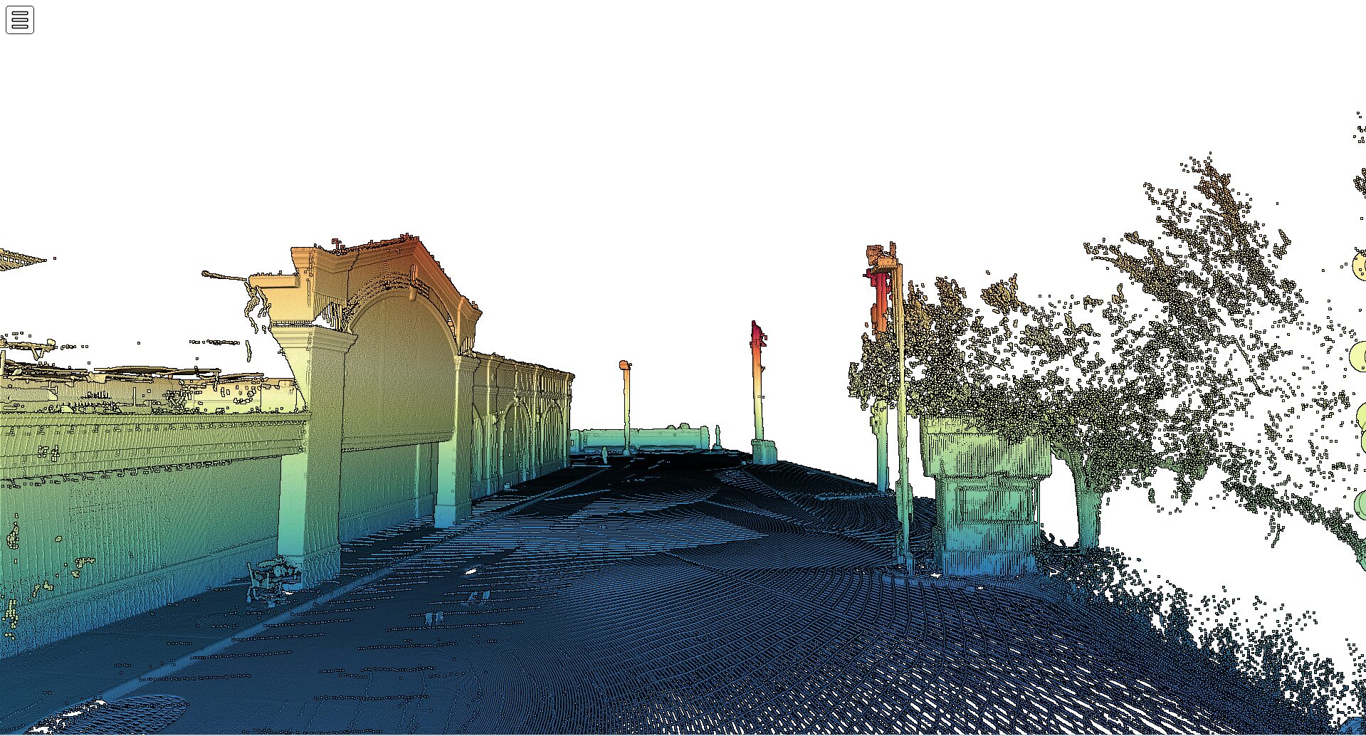
Once the data is cleaned, the next step is point cloud processing. This involves organizing the raw LiDAR data into a structured format for further analysis. Point cloud processing includes tasks like segmentation, registration, and density normalization. Segmentation divides the point cloud into distinct sections based on certain criteria, such as elevation or reflectivity. Registration aligns multiple point clouds collected from different locations or times to create a cohesive dataset. Density normalization ensures a uniform distribution of data points across the surveyed area.
Classification and Feature Extraction
Classification is a critical step in LiDAR data processing, where data points are categorized into different classes, such as ground, vegetation, buildings, and water. This classification is crucial for many applications, including creating Digital Elevation Models (DEMs) and Digital Terrain Models (DTMs). Feature extraction involves identifying and isolating specific features from the LiDAR data, such as building edges, tree canopies, power lines, and road markings. This information is vital for various civil engineering tasks, including urban planning, architecture, and infrastructure management.
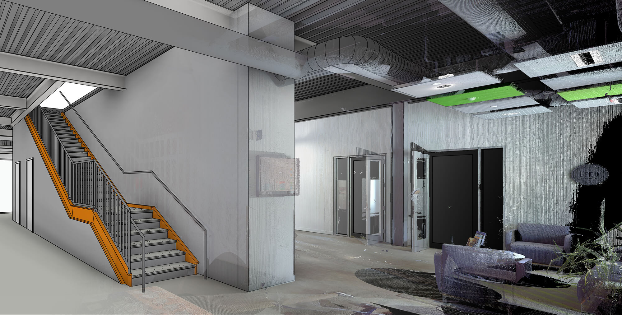
3D Modeling and Change Detection
Using classified LiDAR data, engineers can create detailed three-dimensional models of structures, landscapes, and urban environments. These 3D models are essential for visualizing the impact of proposed infrastructure projects and communicating with stakeholders. A specific application of this is the Railroad LiDAR solution, which allows for the precise modeling of rail corridors, enabling engineers to assess the condition of tracks, surrounding terrain, and nearby structures. This solution facilitates effective planning and decision-making for rail infrastructure development and maintenance.
Change detection is another important application of LiDAR data, where datasets taken at different times are compared to identify changes in the environment or infrastructure. For railroads, the Railroad LiDAR solution is particularly valuable as it helps in monitoring the condition of tracks, detecting potential issues such as track displacement or vegetation encroachment, and ensuring the safety and reliability of rail services. This capability is crucial for monitoring construction progress, assessing damage after natural disasters, and planning maintenance activities, ensuring that railroad operations remain safe and efficient.
Integration with Other Data Sources
LiDAR data processing does not occur in isolation; it is often integrated with other data sources, such as aerial photographs, satellite imagery, and GIS data. This integration enhances the accuracy and comprehensiveness of the final output, providing a more holistic view of the surveyed area. By combining LiDAR data with other datasets, engineers can create detailed maps and models that support better decision-making.
Conclusion
The multifaceted process of LiDAR data processing involves several stages, each of which is crucial for transforming raw data into useful information. From data collection and cleaning to 3D modeling and integration with other data sources, each step plays a vital role in ensuring that civil engineers have the accurate, detailed data they need to make informed decisions. By understanding this process, engineers can leverage LiDAR technology to enhance the accuracy, efficiency, and sustainability of their projects.
Related Articles
-
How 3D Laser Scanning Services Are Reshaping Building Projects Across the US
CONTINUE READING -
Understanding LiDAR Technology: A Comprehensive Guide to Its Applications in Civil Engineering
CONTINUE READING -
Revolutionizing Civil Engineering: The Impact of LiDAR Technology on Infrastructure Development
CONTINUE READING