Over the past few years, geospatial technology has become an increasingly accurate tool for mapping the world. Today, this technology is used to optimize physical spaces and assets in a multitude of ways, resulting in more sustainable and efficient uses of resources in many different industries.
This article will take a look at more specific geospatial technologies and the way they can be used to help better optimize physical spaces for more efficient projects.
What is geospatial technology?
The term “geospatial technology” refers to a group of modern tools that contribute to the geographic mapping of both human society as well as Earth itself. With roots spanning all the way back to primitive cartography in prehistoric eras, contemporary geospatial technologies are advancing rapidly. Over the past few centuries, they have evolved from traditional cartography and mapmaking to cameras held aloft on airplanes, satellites, and other vehicles.
Today, geospatial technology consists of both mobile, land-based tools and satellite-based images. These advances have made the technology more accessible and have resulted in an increase in real-time analysis and data processing. And as computational power and network speeds continue to increase, geospatial technology is poised to revolutionize the process of optimizing physical assets in real-time.

Combining ICT and SDT
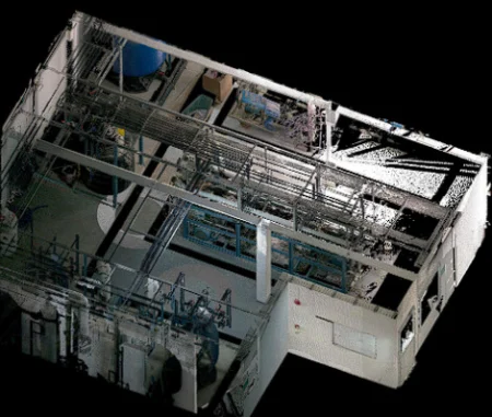
Informational and Communications Technology (ICT) and Spatial Digital Twins (SDT) are geospatial technologies that are most effectively used together. When combined, these technologies lead to the creation of intelligent and advanced systems used to optimize and simulate the way physical spaces and assets are used in real-time. They have complementary features that render them capable of mapping out not just virtual representations of physical spaces and assets, but also the way that communication moves within them.
The ability to both map spaces and assets as well as to analyze how they are being used leads to real-time insights that allow for improved maintenance and informed decisions about optimizing performance and avoiding problems. Combining ICT and SDT technology also creates the potential for collaboration and enhanced communications between stakeholders involved in the maintenance and management of the physical spaces in question.
More specifically, ICT and SDT combined allow for the creation of a detailed virtual representation of physical spaces as well as the “traffic” within them. The technologies offer monitoring of many different elements of the physical environment, too, including:
- Humidity
- Temperature
- Lighting
- Occupancy
With access to these aspects of the environment, experts in the geospatial sphere have the ability to create highly accurate simulations, allowing the impact of each element on the space and its assets to be recorded. Optimizing the performance of assets within the buildings, including vehicles, machines, and buildings, is comparably easy when you can do a “trial run” of operation decisions on a simulation before you mess with the real deal, too.
The combination of ICT and SDT has already proven incredibly beneficial. Cities of all sizes have used these technologies to help cope with the growing complexity of disseminating, exchanging, and producing information among varied infrastructures. With highly accurate virtual simulations, officials are able to determine how “smart city” initiatives can be used effectively within their regions to make the flow of telecommunications between space and urban sources more reliable. This, in turn, makes it easier to pick viable transformations and implement them without running into unknowns that complicate the process.
The Takeaway
Combining ICT and SDT can lead to the creation of intelligent and advanced systems simulating active and physical spaces in real-time so they can be optimized on the fly. Overall, this pairing stands to improve the sustainability, efficiency, and resilience of assets and physical spaces for a more connected world.