LiDAR technology, which stands for Light Detection and Ranging, has become a game-changer in the field of civil engineering. This advanced remote sensing technology provides high-resolution, three-dimensional data that has revolutionized the way infrastructure projects are planned, designed, and managed. LiDAR’s ability to capture detailed topographical information quickly and accurately makes it an invaluable tool for engineers.
Surveying and Mapping
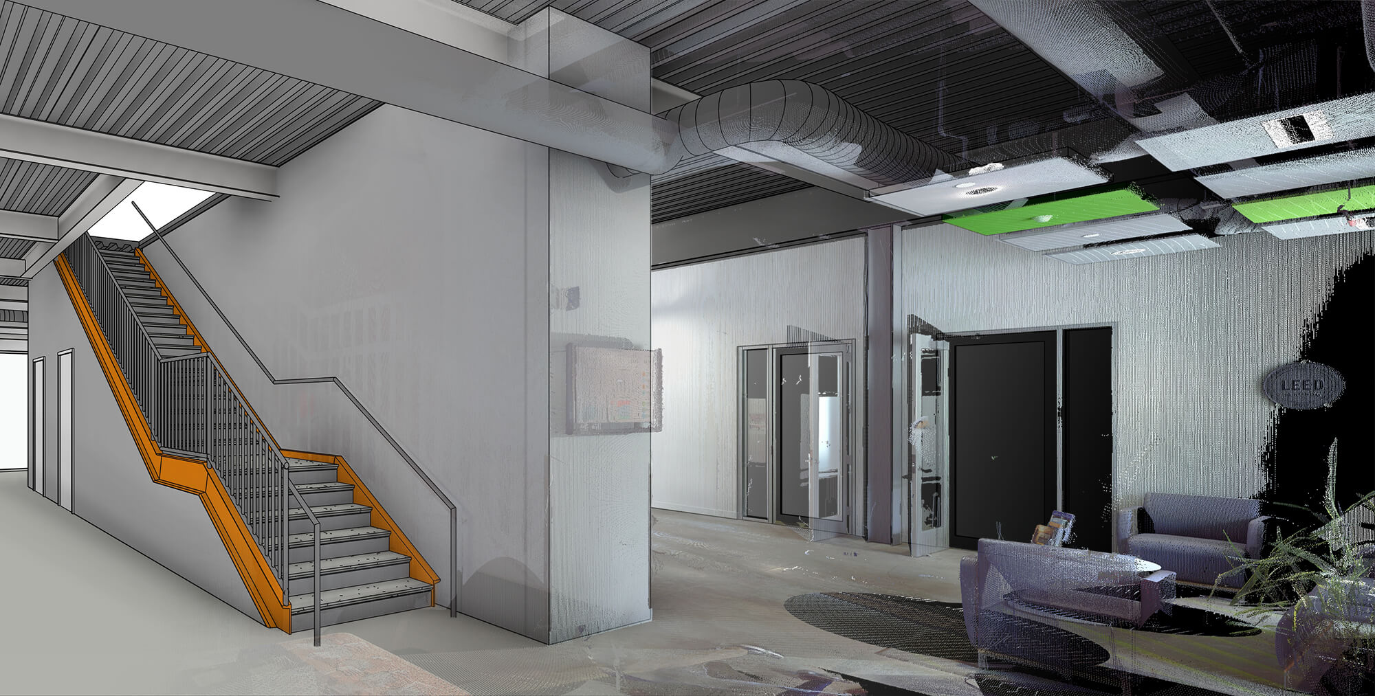
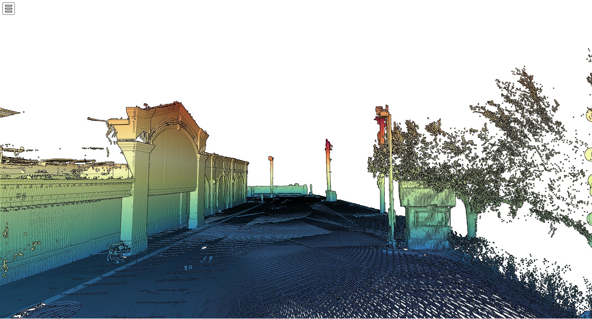
One of the primary uses of LiDAR in civil engineering is for surveying and street mapping. Traditional surveying methods are time-consuming and often limited by the accessibility of the terrain. LiDAR, however, enables rapid topographical surveys over large areas with exceptional accuracy. It can be used to create detailed 3D models of the terrain and built environment, helping engineers visualize new projects within the existing context. This capability is particularly useful in remote or difficult-to-access areas where traditional surveying would be impractical.
Design and Planning
LiDAR technology is also crucial during the design and planning phases of infrastructure projects. The precise measurements of distances, elevations, and volumes provided by LiDAR data are critical for accurate design work. Engineers can use this data to simulate various scenarios, such as flood modeling or the impact of structural changes on the surrounding area. These simulations help in making informed decisions, ensuring that the design is both effective and sustainable.
Construction and Monitoring
During construction, LiDAR can be used to monitor progress and ensure that the work conforms to design specifications. High-resolution LiDAR scans help detect deviations from planned construction, enabling prompt corrective actions. Additionally, LiDAR is used for calculating earthwork volumes, which is crucial for cost estimation and logistics during the construction phase. This technology ensures that projects stay on track and within budget. RealityIMT offers best lidar scanning Services nationwide.
Preservation and Retrofitting
LiDAR is not only useful for new construction projects but also for the preservation and retrofitting of existing structures. It can be used to document the current state of historical structures for preservation or to guide restoration efforts. Engineers can analyze LiDAR data to assess the conditions of existing structures, determining the need for retrofitting or rehabilitation. This application is particularly valuable in areas prone to natural disasters, where structural integrity is paramount.
Environmental and Land Use Planning
LiDAR technology also plays a significant role in environmental and land use planning. It helps in assessing the environmental impact of proposed projects by providing detailed before-and-after snapshots of the landscape. With comprehensive data from LiDAR scans, civil engineers can make informed decisions regarding land use and sustainable development. This application is increasingly important in the context of climate change and the need for sustainable infrastructure solutions.
Conclusion
In summary, LiDAR technology has transformed the field of civil engineering by providing comprehensive data that underpins every phase of a project, from initial planning to construction and maintenance. Its ability to quickly gather detailed, accurate spatial information has not only improved the efficiency and accuracy of civil engineering projects but also opened up new possibilities for innovation and development.
Related Articles
-

How 3D Laser Scanning Services Are Reshaping Building Projects Across the US
CONTINUE READING -

Understanding LiDAR Technology: A Comprehensive Guide to Its Applications in Civil Engineering
CONTINUE READING -

From Data Collection to Decision Making: The Multifaceted Process of LiDAR Data Processing in Civil Engineering
CONTINUE READING