
Nationwide Service | Houston Headquarters

Geospatial Mapping, Utility Mapping

Street-Level Imagery for Electric Utility Asset Management

This buyer guide explains how electric utilities can plan and procure street-level imagery programs for asset inspection, GIS integration, route documentation, and long-term asset management. It covers camera selection, positioning accuracy, field operations, data processing, QA/QC, and RFP requirements.

Primary Asset
Distribution Infrastructure
Capture Options
Panoramic or Directional Imagery
Positioning
GNSS/INS and Control
Outputs
Imagery, Asset Tags and GIS Data

Overview

Utility Imagery Programs Should Begin with the Asset Workflow

Street-level imagery can help utility teams review poles, equipment, access conditions, vegetation, crossings, and surrounding context without sending every stakeholder into the field.

The camera system is only one component. A successful program must also define route planning, positioning, image quality, data management, asset tagging, GIS integration, QA/QC, security, hosting, and training.

The best configuration depends on what the utility intends to extract from the imagery and how the information will be maintained.
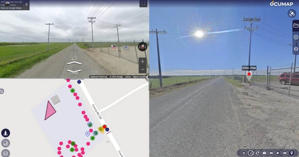
Street-level imagery of electric utility distribution infrastructure

Article Details

Content Type
Primary Audience
Reading Time

Camera Configuration

Panoramic vs. Directional Imagery

Panoramic systems provide broad context around the route and can reduce blind spots. Directional or dual-camera systems may be appropriate when the required features are concentrated on one or both sides of the roadway.

The correct choice should be based on feature visibility, required image quality, operating speed, mounting height, storage, and review workflow rather than camera specifications alone.

Positioning

Location Accuracy and Orientation

Imagery must be tied to position so users can follow the route and associate observations with utility assets. GNSS, inertial navigation, odometers, correction services, survey control, or combinations of these may be used depending on accuracy requirements and operating conditions.

The scope should clearly distinguish route-level location awareness from asset-level surveyed coordinates.

Field Program

Capture Planning and Operations

Route Planning

Define service territory, road classes, easements, off-road segments, revisit requirements, and daily coverage.

Mounting and Calibration

Establish repeatable camera geometry, positioning offsets, and field checks.

Lighting and Image Quality

Plan for sun angle, weather, shadows, motion, speed, and feature visibility.

Data Handling

Define onboard storage, transfers, naming, backups, and chain of custody.

Off-Road Coverage

Identify where ATV, walking, UAV, or other platforms are needed.

Safety and Traffic

Address vehicle operation, traffic exposure, railroad crossings, and restricted areas.

Data Workflow

From Imagery to Utility Asset Information

1. Processing and Organization

Synchronize imagery and trajectory, review coverage, and organize the route for efficient access.

2. Asset Tagging and Classification

Define asset types, attributes, condition fields, confidence, and review rules before production tagging begins.

3. QA/QC

Check image quality, route completeness, positioning, duplicate records, asset coding, and exception handling.

4. GIS and Enterprise Integration

Define required schemas, IDs, coordinates, attachments, APIs, file formats, and relationships with the utility’s system of record.

5. Hosting and Retention

Set permissions, security, retention periods, update cycles, and ownership of raw and processed data.

Procurement

What a Utility RFP or Scope Should Specify

Program Purpose

Inspection, asset inventory, pole attachment review, vegetation, outage support, construction, or a combination.

Coverage and Frequency

Mileage, routes, revisits, seasons, and change-detection needs.

Image Requirements

Resolution, field of view, speed, lighting, metadata, and acceptable obstructions.

Position Requirements

Route-level, asset-level, or survey-controlled accuracy expectations.

Data Model

Required asset fields, naming conventions, IDs, and GIS schema.

Acceptance Criteria

Coverage, quality, accuracy, production rate, security, and delivery requirements.

Intended Audiences

Who This Guide Is For

Electric Utilities
GIS
Inspection
Asset Management Teams
Utility Managers
GIS and Engineering Teams

Planning a Utility Imagery or Asset-Mapping Program?

Send us the service territory, asset types, positioning requirements, GIS workflow, and intended update cycle.